
In the middle of the night I woke to thunder and lightning and pouring rain. In the morning there was drizzle but by the time Lee invited us to the house for breakfast, it started pouring again. Breakfast was awesome and we just sat around for at least two hours and talked.

A lot of rain last night

The bunkhouse in the distance

Jim's bike and weekend home

From left to right: Lee, his daughter, me, Jim
By 10:30AM it had stopped raining and there were some blue skies visible between the rain clouds. It was time to hit the road. Tony left me a message to call him. He was staying at a motel in International Falls. I called him back and we decided to meet up at the corner of 11 and 71, but I didn’t know when we would be there, we still had to pack up the bikes. After some pictures, we left the Ripple Inn, as Lee’s family calls it, and followed Lee to the Big Falls. He said “you can’t come to Big Falls and not see the falls”. We hung out by the river and took some pictures. The river water was orange in color, which was pretty neat. Jim and I said good bye to Lee and we headed on our way.


Looks like root beer


Lee's daughter and me

By the time we left Big Falls it was totally sunny and warm. It looked like another great riding day. We headed northeast on 71, but before we got to the corner of 11 a BMW GS passed us and waved and then pulled over on the shoulder. That wave was somehow different from a 'hello' wave, so I pulled over on the shoulder and the BMW rider made a u-turn and pulled over next to us. Apparently this guy and Tony had been talking earlier at the gas station and Tony left a message with him to tell us he had to run out for a bit but he’ll be back to meet us at the gas station later on. We arrived at the corner of 71 and 11, and parked at the gas station. Tony wasn't there yet. They didn't have any Red Bull, so I got some other stuff that tasted like cherry flavored cold medication. Then I sat down with the map to figure out how to make the route for today shorter. I had originally planned to ride 520 miles but it was already 12PM. Tony showed up about 30 minutes later and since he was hungry and there was a café at the gas station, we decided to just have lunch and get that over with.

Lunch in Pelland, MN at the gas station
After lunch we headed West on 11, also called the Waters of the Dancing Sky byway, named for the northern lights that can often be seen dancing in the sky during the summer nights. This is Minnesota's northernmost byway. This route travels 191 miles along the Canadian border through lakes, the legendary Rainy River, forests, farmland, and several towns.
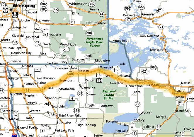
Highlighted is the Waters of the Dancing Sky byway which is 191 miles long
With the late start we only rode the scenic byway 11 as far as Roseau, about 100 miles. It was starting to get a bit windy and more clouds were rolling in. The further we went the windier it got. From Pelland to Baudette, the road travels through forests along the Rainy River and has many high speed sweepers. This was my favorite section of 11. On top of that, there was hardly any traffic on this section of the road. In Baudette, another giant walleye statue greets visitors. I somehow missed the 40-ft. long Willie the Walleye, which weights about two tons. When I rode in to town I was already feeling beat up from the wind. I kept thinking we had so many more miles to go yet. I remember looking at the bridge across the water to the right thinking of maybe pulling over for some pictures. The scenery was nice, but with pulling over for pictures it's never a 5 minutes of less type of thing, so I dismissed that thought and kept going. From there to Roseau, the road is mostly straight running through farmland, and there was more traffic too. We would have lost nothing by skipping that section, especially since we had no time to check out the water front or go to the Angle Inlet, the northernmost part of Minnesota.

Very windy by the Canadian border, a tornado is spotted just a few miles away
By the time we pulled over in Roseau, the winds were blasting. I almost dropped my bike in the parking lot because of the wind, it almost pushed me over bike and all. On the radio at the gas station they were reporting tornado just a few miles from us in Canada, the skies looked dark and menacing in that direction. The storm last night hit this area hard. We turned South on 89 and I was hoping since we were riding away from the storm, we would be riding away from the source of the wind. But the windy conditions continued. But it wasn’t like normal wind, it wasn’t even gusty. The air was just turbulent. The wind would keep pushing me mostly to the left, then violently change direction and push me to the right, which I could not prepare for so I would end up getting catapulted to the edge of my lane, then back to the other side. It felt like an invisible person was holding my helmet and pulling it in all different directions the whole time. Let’s just say riding was not as fun as I wanted it to be, at least there was hardly any traffic here. At times the road would change direction and travel East, and there would be no wind what so ever, but for the most part it would travel South and it was very windy. The Northern part of 89 traveled though the open fields and the southern through lakes and forests. There was the occasional sweeper here and there, but through the Red Lake Indian reservation there were a few nice and curvy sections and nice views as the road traveled along the edge of Red Lake. This was also where a deer decided to cross the road just ahead of my bike. But I had plenty of distance to react.
We turned East on 2 and headed toward Bemidji. We stopped for gas and I wanted to check the progress of our route. It was already 6PM so I implemented another short cut shaving another 30 miles from the route. The temperature was only in the low 70’s today, now it was getting cooler so I added another layer and we continued south on 2. The road I was looking for was indicated as county 7 on my paper map but on Jim’s and Tony’s paper maps it was county 3. The detail wasn’t really great but on all 3 maps it looked like we could catch this road from 2. Just shortly after we got on 2 I saw an exit for 7, so we took this exit, but the road was going west and the sign indicated a town in the distance that I was not familiar with. The only town my map showed me was Becida. I made us turn around thinking this was not it. Maybe I should have been looking for 3 instead, maybe my map was wrong. We continued on 2 which traveled south for a bit, there was no exit for 3 anywhere, then the road turned and started heading east again, away from where we needed to go. I pulled over and had Tony look at his GPS. We devised an emergency escape route from here that would lead us to the next road we had to be on which was 71. Too bad, by not finding this road we wanted to ride we missed our opportunity to stop at the Mississippi headwaters, which we all wanted to see.
Totally sucks when the leader doesn’t have a GPS (that would be me). Tony led the way. At Cass Lake we took an exit for 371 South and took that to 200 West. Both roads were nice with great scenery, some lazy curves, many lakes, forests and little traffic. At the 71 junction, we turned south, there was more traffic here, the road was sort of straight but very scenic with many lakes below to the right and left. I wanted to pull over and grab some pictures, since there was a shoulder on this road, but we were riding pretty fast and by the time I saw the lake, we were already passing it. I finally ended up pulling over missing the lake by a few feet since I didn’t want to slam on the brakes with two bikes behind me. The lake was still visible thought the trees and since the sun was setting in that direction, having trees in the way made for a nice effect.

From left to right: my bike, Tony with his Trophy and Jim with his Connie

Just as we were preparing to take off again a Honda Valkrie pulled over towing a trailer. Not a motorcycle trailer either, a big metal frame trailer with regular sized tires, a trailer like a car would be towing. I didn’t talk to the guy, I was already getting ready to leave, so I don’t know the deal with the trailer, but the guy took off and he had loud explosive pipes on that bike.
We turned west on 113 and the curves started immediately, not too many straight sections on this road. This road was recommended to me and the reason why we were even riding in this direction today. Curves posted at 40-45MPH to the left and right, many “S” type curves, just a great road to rail on at high speeds. Which I attempted to do but the sun was low on the horizon and we were traveling west in to the sun. With each turn I was blinded, not even able to see the road. Then once I plunged in to the shadows my eyes took a few seconds to re-adjust, then back in to the blazing sun again. The sun was playing havoc on my eyes and the idea that there were deer in these woods wasn’t comforting.
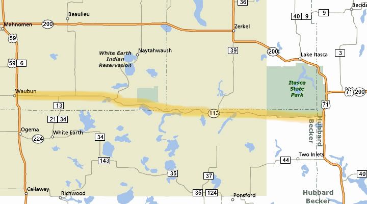
113 in Northwest Minnesota, what a wonderful road
We caught up to the guy on the Valkrie as he rode through the curves ahead of us. After a few curves I even thought of passing him, even though he wasn’t going slow at all. His trailer was shooting up all kinds of gravel though. Then I saw a deer jump out in front of him and I quickly decided to stay where I was and watch the road ad the woods a bit better. There were a few scenic pullouts here on 113 but I had a hard time reading the road signs with the sun in my eyes so I missed all of them, too bad, one scenic stop overlooked a lake, that would have been a great picture.
Once we got to Waubun we stopped to put on more layers and change our tinted shields to clear ones. Then we turned south on 59. We stopped for gas in Detroit Lakes and took off again quickly. There were a lot of tiny little bugs flying around and my shield was getting covered by the nasty things. There was also a lot of traffic on this road. Now it was completely dark and many towns were shooting off fireworks, the nearby lakes were reflecting the colorful lights as we passed by them. Smoke from the fireworks hovered over the road in places. I caught a magnificent display of fireworks as I crossed over a bridge near Pelican Rapids, colors exploding above and below me. I don’t really care for fireworks but this was really neat.
We made it to the end of 59 in Fergus Falls and took I-94 East one exit over to the 210 where I had a reservation at the Best Western. By the time I checked in, unloaded the bikes and got up to the room it was already 11PM. The Best Western had a Bar & Grill inside and when I made the reservations I specifically asked if it would be open on Sunday, July 3rd. I was told that it’s open every day. Guess what, it was closed because of the holiday. We went up stairs to get our jackets and walked across the parking lot to Perkins, which was packed. We waited at least 15-20 minutes before we even got a table. By the time we made it back to the motel it was already 1AM. I wanted to leave early tomorrow morning but I also needed to get some sleep. I decided to have my alarm go off at 6:30AM. Hopefully the nice weather would return for tomorrow's ride home.

No comments:
Post a Comment